

Hiking Schedule (Archived)
Monday March 24, Intermediate Monday March 24 Monday March 31, Advanced Monday April 7, Intermediate Monday April 7, Trail Maintenance Wednesday April 9, Novice Monday April 14, Advanced Monday April 21, Intermediate Saturday April 26, Novice Monday April 28, Advanced Friday May 2, Trail Maintenance Monday May 5, Intermediate Saturday May 10, Intermediate Monday May 12, Advanced Wednesday May 14, Novice Monday May 19, Intermediate Monday May 19, Advanced Monday May 19 Friday May 23, Trail Maintenance Saturday May 31, Novice Monday June 2, Intermediate Saturday June 7, Intermediate Monday June 9, Advanced Wednesday June 11, Novice Monday June 16, Intermediate Saturday June 21, Novice Monday June 23, Advanced Monday June 30, Intermediate Monday July 7, Advanced Wednesday July 9, Novice Monday July 14, Intermediate Saturday July 19, Novice Monday July 21, Advanced Monday, July 28, Intermediate Directions to the Sawyer Savings Bank: From I-87 (Exit 20), proceed
east on route 212/32 approximately one mile to a fork in the road. Make a
left onto Market Street at the fork. The bank will be on your immediate
right, at 87 Market Street.
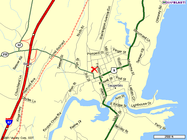
Click
Here for a map of Saugerties. The red X represents the location of
Sawyer Savings Bank.
For hikes to the Central/Western Catskills (areas accessible primarily
via Route 28), it may be possible to meet the group at the rear of the
Mountainside Restaurant parking lot, Route 28 and Maverick Road. This must
be pre-arranged with the hike leader. Bob Saturn, President, (845) 246-7158
or
Sally Colclough, Membership Chairman, (845) 246-2945
* The figure given represents the elevation of the summit. The total
ascent of the hike will be less.
Trail Maintenance = special maintenance hikes Rain Dates will be the following Monday for Monday Hiking involves certain inherent hazards, and persons
Saturday March 22, Novice
Meet - 10:00 AM
Location:
Marist College Campus
Distance: 4.0 miles, 3.0 hours, easy
For
Further Info Call: (845) 246-2945
Meet - 8:00 AM
Location: Harlem
Valley Rail Trail
Distance: 7.0 miles, 4.0 hours, easy
For Further
Info: (845) 246-5670
Bi-Monthly Meeting
Meet - 7:00 PM
Atonement
Lutheran Church
Meet - 8:00 AM
Location: Doubletop
Mountain (3860')*, Ascent 1850'
Distance: 5.5 miles, 5.25 miles,
strenuous bushwhack
For Further Info Call: (845) 247-8756
Meet - 8:00 AM
Location: Wilson
State Park
Distance: 6.0 miles, easy
For Further Info Call: (845)
246-5447
Meet - 8:00 AM
Location: Long
Path (Platte Clove section)
plus Kaaterskill High Peak (3655')
optional
Distance: 5.0 miles, 5.0 hours, moderate
For Further Info
Call: (845) 246-8616
Meet - 9:00 AM
Location: Wilson State
Park
Distance: 6 miles, easy
For Further Info Call: (845) 679-9763
Meet - 8:00 AM
Location: Southwest
Hunter Mountain (3740'), Ascent 2200'
Distance: 5.5 miles, 5.5 hours,
Strenuous Bushwhack
For Further Info Call: (845) 246-7987
Meet - 8:00 AM
Location: Acra Point
(3100'), Ascent 900'
Distance: 5.3 miles, 4.0 hours, moderate
For
Further Info Call: (845) 246-4145
Meet - 9:00 AM
Location: Harlem Valley
Rail Trail
Distance: 6.0 miles, easy
For Further Info Call: (845)
246-4590
Meet - 8:00 AM
Location: Plateau
Mountain (3840'), Ascent 1800'
Distance: 5.5 miles, 4.25 hours,
strenuous
For Further Info Call: (845) 246-4040
Meet - 8:00 AM
Location: Long
Path (Twilight Park to Palenville)
Distance: 5.0 miles, 5.0 hours,
moderate
For Further Info Call: (845) 246-8616
Meet - 8:00 AM
Location: Mount
Greylock, MA (3191')
Distance: 9.3 miles, 6.5 hours, strenuous
For
Further Info Call: (845) 246-4590
Meet - 9:00 AM
Location: Esopus
Creek Trails, Saugerties
Distance: 2.0 miles, moderate
For Further
Info Call: (845) 247-0664
Meet - 8:00 AM
Location: Eagle Mountain
(3600'), from Seager trailhead
Distance: 8.4 miles, 5.0 hours,
strenuous
For Further Info Call: (845) 679-2580
Meet - 9:00 AM
Location: Manitoga,
Garrison in Putnam County
walk plus house tour (fee
required)
Distance: 6.0 miles, easy
For Further Info Call: (845)
246-7174
Meet - 8:00 AM
Location: Indian Head
Mountain (3573'), Ascent 1780'
Distance: 7.0 miles, 4.25 hours,
strenuous
For Further Info Call: (845) 246-6949
Meet - 7:00 AM
Location: Peekamoose
(3843') and Table (3847') Mountains,
Ascent 1800', with option of Lone
(3720') & Rocky (3508')
Distance: 10.0 miles, 8.0 hours,
strenuous
For Further Info Call: (845) 246-8616
Bi-Monthly Meeting
Meet - 7:00 PM
Atonement
Lutheran Church
Meet - 8:00 AM
Location: Thomas
Cole Mountain (3940')
Distance: 5.0 miles, 5.0 hours, strenuous
For
Further Info Call: (845) 246-8616
Meet - 8:00 AM
Location: Fahnstock State
Park, Hudson Highlands
Distance: 6.0 miles, moderate walk
For
Further Info Call: (845) 758-0769
Meet - 8:00 Am
Location: Sam's Point
(With Ice Caves & Falls option - Bring a flashlight) Distance: 5.0
miles, 5.0 hours, moderate
For Further Info Call: (845) 658-8606
Meet - 8:00 AM
National Trails Day
Hike
Location: Huckleberry Point
Distance: 4.8 miles, 3.5
hours
For Further Info Call: (845) 246-4145
Meet - 8:00 AM
Location: Balsam Cap
(3623') and Friday (3694') Mountains
total ascent of 3000'
Distance:
7.5 miles, 7.5 hours, strenuous bushwhack
For Further Info Call: (845)
246-1823
Meet - 8:00 AM
Location: Taconic Crest
Trail from Petersburgh Pass to the
Snow Hole, near
Williamstown
Distance: 5.0 miles, all day event, easy
For Further
Info Call: (845) 246-7174
Meet - 8:00 AM
Location: Twin
Mountain (3640')
Distance: 5.0 miles, 5.0 hours, moderate +
For
Further Info Call: (845) 246-7616
Meet - 8:00 AM
Location: Rochester
Hollow (Matyes Rd. off Routet 28)
Distance: 6.0 miles, 3.0 hours,
easy
For Further Info Call: (845) 246-4590
Meet - 8:00 AM
Location: Sugarloaf Mt
(3800'), Ascent 1800', from Mink Hollow
Distance: 4.0 miles, 4.5 hours,
strenuous
For Further Info Call: (845) 246-4040
Meet - 8:00 AM
Location: Echo Lake,
from Platte Clove
Distance: 10.0 miles, 5.0 hours, moderate
For
Further Info Call: (845) 246-6949
Meet - 8:00 AM
Location: Lake Awosting
Circular
Scrambles plus carriage road walking and swimming at
lake
Note: Parking fee about $5 per car (waived if senior
citzen)
Distance: 10.0 miles, 7.0 hours, moderate
For Further Info
Call: (845) 255-0614
Meet - 8:00 AM
Location: Mountain Top
Arboretum
Distance: 3.0 miles, 2.0 hours, easy
For Further Info
Call: (845) 246-2459
Meet - 8:00 AM
Location: Sage's
Ravine in the Taconics, Berkshire County, MA
Distance: 8.0 miles, 5.5
hours, moderate +
For Further Info Call: (845) 246-5670
Meet - 8:00 AM
Location: Thompson Pond
Preserve, Route 82, Pine Plains
Distance: 5.0 miles, 2.0 hours,
easy
For Further Info Call: (845) 246-2945
Meet - 8:00 AM
Location: Westkill
Mountain (3880'), Ascent 1700'
Distance: 7.0 miles, 5.5 hours,
strenuous
For Further Info Call: (845) 679-2580
Meet - 8:00 AM
Location: Black Rock
Forest (north loop), Town of Esopus
Distance: 5.5 miles, 3.5 miles,
moderate
For Further Info Call: (845) 246-4590
You may use the following link to download and print an MS Word
format August/September
schedule. This 'paper' schedule is issued via email to club
members and handed out to those present at the
bi-monthly club planning
meetings.
The meeting place for 'all' hikes is at the rear of the Sawyer
Savings Bank parking lot, 87 Market Street, Saugerties, NY.
For Further Information on
any of the above hikes call:
Hikes are divided into advanced, intermediate and novice levels.
(see Trail Maintenance
in the Main Menu)
hikes, and the
following Saturday for Saturday hikes.
There is no regular rain date
for Wednesday hikes.
participating
do so at their own risk.
![]()
Last updated:
07/28/03 Copyright © 1996-2003, Rip Van Winkle Hikers